View my weather data on Weather Underground-1
Beaufort Wind Scale
| Beaufort Number (FORCE) | Wind Speed | Wave Height (Ft) | WMO* Description | Effects Observed On the Sea | Effects Observed On the Land | |
| Knots | MPH | |||||
| 0 | Under 1 | Under 1 | Flat | Calm | Sea is like a mirror |  |
| 1 | 1-3 | 1—3 | 0.25 | Light Air | Ripples with appearance of scales; no foam crests |  |
| 2 | 4 –6 | 4 –7 | 0.5—1 | Light Breeze | Small wavelets; crests of glassy appearance, not breaking |  |
| 3 | 7-10 | 8-12 | 2-3 | Gentle Breeze | Large wavelets; crests begin to break; scattered whitecaps |  |
| 4 | 11-16 | 13-18 | 3.5-5 | Moderate Breeze | Small waves, becoming longer; numerous whitecaps |  |
| 5 | 17-21 | 19-24 | 6-8 | Fresh Breeze | Moderate waves, taking longer form; many whitecaps; some spray |  |
| 6 | 22-27 | 25-31 | 9.5-13 | Strong Breeze | Larger waves forming; whitecaps everywhere; more spray |  |
| 7 | 28-33 | 32-38 | 13.5-19 | Near Gale | Sea heaps up; white foam from breaking waves begins to be blown in streaks |  |
| 8 | 30-40 | 39-46 | 18-25 | Gale | Moderately high waves of greater length; edges of crests begin to break into spindrift; foam is blown in well-marked streaks |  |
| 9 | 41-47 | 47-54 | 23-32 | Strong Gale | High waves; sea begins to roll; dense streaks of foam; spray may begin to reduce visibility |  |
| 10 | 48-55 | 55-63 | 29-41 | Storm | Very high waves with overhanging crests; sea takes white appearance as foam is blown in very dense streaks; rolling is heavy and visibility is reduced |  |
| 11 | 56-63 | 64-72 | 37-52 | Violent Storm | Exceptionally high waves; sea covered with white foam patches; visibility further reduced |  |
| 12 | 64 and over | 73 and over | 45 and over | Hurricane | Air filled with foam; sea completely white with driving spray; visibility greatly reduced |  |
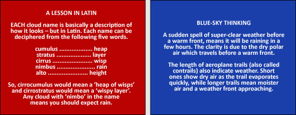
Cloud Types and Altitude
| Low clouds Surface – 7,000 ft |
Medium clouds 7,000 – 17,000 ft |
High clouds 17,000 – 35,000 ft |
Cumulus |
Altocumulus |
Cirrus |
Cumulonimbus |
Altostratus |
Cirrostratus |
Stratus |
Nimbostratus |
Cirrocumulus |
Stratocumulus |